The Nile threading the great S-bend of Nubia

The AtlasالأطلسL'AtlasEl AtlasDer Atlas

Eighteen states. One Sudan. ثماني عشرة ولاية. سودانٌ واحد. Dix-huit États. Un seul Soudan. Dieciocho estados. Un solo Sudán. Achtzehn Staaten. Ein Sudan.

From the pyramids of the river north to the granite domes of the east, the volcano of the west and the wetlands of the south — the whole country, state by state. من أهرامات الشمال النهريّ إلى قباب الشرق الغرانيتية، وبركان الغرب وسهول الجنوب — البلادُ كلُّها، ولايةً ولاية. Des pyramides du nord fluvial aux dômes de granit de l'est, du volcan de l'ouest aux zones humides du sud — tout le pays, État par État. De las pirámides del norte fluvial a las cúpulas de granito del este, del volcán del oeste a los humedales del sur — todo el país, estado por estado. Von den Pyramiden des Flussnordens zu den Granitkuppeln des Ostens, dem Vulkan des Westens und den Feuchtgebieten des Südens — das ganze Land, Staat für Staat.

I

The Northern Regionالإقليم الشماليLa région du NordLa región del NorteDie Nordregion

The corridor of kingdoms — where the Nile bends through Nubia and every cataract hides a capital. ممرُّ الممالك — حيث ينحني النيل عبر النوبة، وكلُّ شلّالٍ يُخفي عاصمة. Le corridor des royaumes — où le Nil serpente à travers la Nubie. El corredor de los reinos — donde el Nilo serpentea por Nubia. Der Korridor der Königreiche — wo der Nil sich durch Nubien windet.

Capital · Dongolaالعاصمة · دنقلاCapitale · DongolaCapital · DongolaHauptstadt · Dongola

Northern Stateالولاية الشماليةÉtat du NordEstado del NorteNordstaat

  • Jebel Barkal — the sacred flat-topped mountain and its Kushite temples.
  • Kerma (Deffufa) — towering mud-brick monuments of Africa's oldest urban civilisation.
  • Old Dongola — ruined capital of Christian Makuria, throne hall and qubbas.
  • Soleb Temple — sandstone temple raised by Amenhotep III.
  • Sai Island — remains from the Stone Age to Ottoman times on one Nile island.
  • Merowe Dam — the "Great Wall of the Nile" at the fourth cataract, 1,250 MW.
  • جبل البركل — الجبل المقدّس المسطّح ومعابده الكوشية.
  • كرمة (الدفوفة) — صروح الطوب اللبن لأقدم حضارة مدنية في أفريقيا.
  • دنقلا العجوز — عاصمة مقرّة المسيحية، قاعة العرش والقباب.
  • معبد صلب — معبد حجري شيّده أمنحوتب الثالث.
  • جزيرة صاي — آثارٌ من العصر الحجري إلى العثمانيين في جزيرة نيلية واحدة.
  • سد مروي — «سور النيل العظيم» عند الشلال الرابع، 1250 ميغاواط.

Capital · Ed Damerالعاصمة · الدامرCapitale · Ed DamerCapital · Ed DamerHauptstadt · Ed Damer

River Nile Stateولاية نهر النيلÉtat du NilEstado del NiloNilstaat

  • Pyramids of Meroë — 200+ steep royal pyramids in the dunes; Sudan's icon.
  • Musawwarat es-Sufra — the Great Enclosure and its elephant carvings.
  • Naqa — the Lion Temple and a Roman-style kiosk, perfectly preserved.
  • Sabaloka Gorge — the Nile narrowing through volcanic rock; boat country.
  • أهرامات مروي — أكثر من 200 هرم ملكيّ حادّ بين الكثبان؛ أيقونة السودان.
  • المصوّرات الصفراء — الحوش الكبير ونقوش الفيلة.
  • النقعة — معبد الأسد والكشك الرومانيّ الطراز، بحفظٍ مدهش.
  • خانق السبلوقة — النيل يضيق بين الصخور البركانية؛ بلاد القوارب.
II

The Eastern Regionالإقليم الشرقيLa région de l'EstLa región del EsteDie Ostregion

Coral seas, granite domes, and the greenest torrents in the desert's shadow. بحارٌ مرجانية، وقبابٌ غرانيتية، وأخضرُ السيول في ظلّ الصحراء. Mers de corail, dômes de granit, torrents verts à l'ombre du désert. Mares de coral, cúpulas de granito, torrentes verdes a la sombra del desierto. Korallenmeere, Granitkuppeln und grüne Sturzbäche im Schatten der Wüste.

Capital · Port Sudanالعاصمة · بورتسودانCapitale · Port-SoudanCapital · Puerto SudánHauptstadt · Port Sudan

Red Sea Stateولاية البحر الأحمرÉtat de la mer RougeEstado del Mar RojoRotmeer-Staat

  • Sanganeb Marine Park — a coral atoll with its British-built lighthouse.
  • Port Sudan reefs — pristine walls, hammerheads in season.
  • Suakin Island — a port town built entirely of coral blocks.
  • Dungonab Bay — UNESCO sanctuary of dugongs and sea turtles.
  • The Umbria wreck — one of the world's great WWII wreck dives.
  • محمية سنقنيب — جزيرة مرجانية حلقية بفنارها البريطاني.
  • شعاب بورتسودان — جدرانٌ بكر، وأسماك المطرقة في موسمها.
  • جزيرة سواكن — مدينة ميناء بُنيت كلُّها من كتل المرجان.
  • خليج دنقناب — محمية يونسكو لأبقار البحر والسلاحف.
  • حطام أومبريا — من أعظم مواقع غوص حطام الحرب العالمية الثانية.
  • حلايب وشلاتين — الساحل الشمالي الشرقي الأقصى، بلاد البجا. اقرأ المزيد ←

Capital · Kassalaالعاصمة · كسلاCapitale · KassalaCapital · KassalaHauptstadt · Kassala

Kassala Stateولاية كسلاÉtat de KassalaEstado de KassalaKassala-Staat

  • Taka Mountains — smooth granite domes towering over the city.
  • Khatmiya Mosque — the Sufi shrine at the mountains' foot.
  • Gash River orchards — fruit groves fed by seasonal torrents.
  • Khashm el-Girba & Upper Atbara dams — the waters of New Halfa.
  • جبال التاكا — قبابٌ غرانيتية ملساء تعلو المدينة.
  • مسجد الختمية — المقام الصوفي عند سفح الجبال.
  • بساتين نهر القاش — بساتين فاكهة تسقيها السيول الموسمية.
  • سدّا خشم القربة وأعالي عطبرة — مياه حلفا الجديدة.

Capital · Gedarefالعاصمة · القضارفCapitale · GedarefCapital · GedarefHauptstadt · Gedaref

Al Qadarif Stateولاية القضارفÉtat d'Al QadarifEstado de Al QadarifAl-Qadarif-Staat

  • Dinder National Park (north) — biosphere of birds, antelope and baboon.
  • Gedaref sesame markets — one of Africa's greatest open-air grain hubs.
  • حظيرة الدندر (الشمال) — محيطٌ حيويّ للطيور والظباء والرُّباح.
  • أسواق سمسم القضارف — من أعظم مراكز الحبوب المفتوحة في أفريقيا.
II · i

Halayeb & Shalateen. حلايب وشلاتين. Halayeb et Shalateen. Halayeb y Shalateen. Halayeb und Schalatin.

Sudan's north-eastern coast — 20,580 square kilometres of Red Sea shore, mountain and Beja grazing land. Disputed territory, claimed by Sudan on the 1902 administrative boundary and under Egyptian de facto administration. ساحل السودان الشمالي الشرقي — 20,580 كيلومتراً مربعاً من شاطئ البحر الأحمر والجبال ومراعي البجا. منطقةٌ متنازع عليها، يطالب بها السودان استناداً إلى الحدّ الإداري لعام 1902، وتخضع لإدارة مصر الفعلية. La côte nord-est du Soudan — 20 580 km² de rivage, de montagne et de pâturages beja. La costa nororiental de Sudán — 20.580 km² de litoral, montaña y pastos beja. Sudans Nordostküste — 20.580 km² Rotmeerküste, Berge und Beja-Weideland.

Where the Red Sea coast runs north from Port Sudan, the shore does not stop at a line of latitude. It carries on through Abu Ramad, the port of Halayeb and the settlement of Shalateen — a stretch of mountain, wadi and coral coast that has belonged to the Beja for as long as anyone has counted.

Two lines on a colonial map

In 1899 the Anglo-Egyptian Condominium Agreement drew a political boundary straight along the 22nd parallel north — a surveyor's line, indifferent to who actually lived there. Three years later, on 4 November 1902, Britain drew a second line: an administrative boundary intended to reflect the real use of the land by the tribes of the region.

That 1902 line placed the territory north of the parallel — the grazing lands of the Bishareen, a Beja sub-tribe — under Sudanese administration, because the people there belonged to Sudan's east and answered to the governor in Khartoum, not Cairo. Sudan has held to the 1902 boundary ever since independence in 1956, and in its own claim and official presentation the area belongs to Red Sea State. Egypt has exercised de facto administration since the mid-1990s.

A land of the Beja

The case was never really about cartography. It is about kinship. The Bishareen and Ababda who live between Halayeb and Shalateen are the same Beja people who fill the markets of Port Sudan and Kassala, speak the same Tu-Bedawie, herd the same camels, and carry the same swords at the same weddings. Around 24,000 people live at Shalateen alone.

It is austere, dramatic country: granite peaks rising off the water, Mount Shendib at 1,911 metres, seasonal wadis running green after rain, and a coral coastline continuous with the reefs of Sanganeb and Dungonab to the south.

Where the matter stands

Egypt asserts the 1899 parallel and has exercised de facto control since the mid-1990s. Sudan maintains the 1902 administrative boundary and has consistently called for the question to be settled by international arbitration — the ordinary, lawful means of resolving such a claim between neighbours. This archive maps the territory as Sudanese, on the 1902 line, and states the position plainly.

حيث يمتدّ ساحل البحر الأحمر شمالاً من بورتسودان، لا يتوقّف الشاطئ عند خطِّ عرض. بل يمضي عبر أبو رماد وميناء حلايب وبلدة شلاتين — امتدادٌ من الجبل والوادي والساحل المرجاني، ملكُ البجا منذ أن بدأ العدّ.

خطّان على خريطةٍ استعمارية

في عام 1899 رسمت اتفاقية الحكم الثنائي الإنجليزي-المصري حدوداً سياسية مستقيمة على خطِّ العرض الثاني والعشرين شمالاً — خطُّ مسّاحٍ لا يعنيه من يسكن هناك فعلاً. وبعد ثلاث سنوات، في الرابع من نوفمبر 1902، رسمت بريطانيا خطاً ثانياً: حدوداً إدارية غايتها أن تعكس الاستخدام الحقيقي للأرض من قبائل المنطقة.

وضع خطُّ 1902 الإقليمَ شمال خطِّ العرض — مراعي البشاريين، إحدى قبائل البجا — تحت الإدارة السودانية، لأن أهله ينتمون إلى شرق السودان ويرجعون إلى الحاكم في الخرطوم لا في القاهرة. وقد تمسّك السودان بحدود 1902 منذ الاستقلال عام 1956، وهي في مطالبته وعرضه الرسميّ جزءٌ من ولاية البحر الأحمر. وتمارس مصر إدارةً فعليةً عليها منذ منتصف التسعينيات.

أرضُ البجا

لم تكن المسألة يوماً في الخرائط. إنها في النسب. فـالبشاريون والعبابدة الساكنون بين حلايب وشلاتين هم البجا أنفسهم الذين يملأون أسواق بورتسودان وكسلا، يتحدّثون البداويت نفسها، ويرعون الإبل نفسها، ويحملون السيوف نفسها في الأعراس نفسها. ويسكن شلاتين وحدها نحو 24 ألف نسمة.

إنها بلادٌ قاسيةٌ مهيبة: قممٌ غرانيتية تنهض من الماء، وجبل شنديب على 1911 متراً، ووديانٌ موسمية تخضرّ بعد المطر، وساحلٌ مرجاني متّصلٌ بشعاب سنقنيب ودنقناب جنوباً.

موقف المسألة

تتمسّك مصر بخطِّ 1899 وتُمارس سيطرةً فعلية منذ منتصف التسعينيات. ويتمسّك السودان بالحدود الإدارية لعام 1902، وقد دعا مراراً إلى حلّ المسألة عبر التحكيم الدولي — الوسيلة القانونية المعتادة لتسوية مثل هذا الحقّ بين الجارين. وهذا الأرشيف يرسم الإقليم سودانياً، على خطِّ 1902، ويقول الموقف صريحاً.

Sources: Anglo-Egyptian Condominium Agreement, 1899, and the British administrative boundary of 4 November 1902 · Wikipedia, Halaib Triangle and Shalateen · CIA, Sudan — Administrative Divisions map, which carries the note: "Sudan claims but Egypt de facto administers security and economic development of the Hala'ib Triangle north of the 22nd parallel boundary" · WorldAtlas, The Egypt–Sudan Border Dispute.
المصادر: اتفاقية الحكم الثنائي 1899، والحدود الإدارية البريطانية في 4 نوفمبر 1902 · ويكيبيديا، مثلث حلايب وشلاتين · خريطة وكالة الاستخبارات الأمريكية التقسيمات الإدارية للسودان، وفيها الملاحظة: «السودان يطالب بمثلث حلايب شمال خطِّ العرض 22 ومصر تُدير أمنه وتنميته فعلياً» · WorldAtlas.
III

The Central Hubsالمراكز الوسطىLes centres du milieuLos centros del medioDie Mitte

Where the two Niles marry, and the breadbasket spreads between them. حيث يتزوّج النيلان، وتمتدُّ سلّةُ الغذاء بينهما. Où les deux Nils se marient, et le grenier s'étend entre eux. Donde los dos Nilos se casan, y el granero se extiende entre ellos. Wo die beiden Nile heiraten und die Kornkammer sich dazwischen ausbreitet.

Capital · Khartoumالعاصمة · الخرطومCapitale · KhartoumCapital · JartumHauptstadt · Khartum

Khartoum Stateولاية الخرطومÉtat de KhartoumEstado de JartumKhartum-Staat

  • National Museum of Sudan — salvaged temples, the great Nubian collections.
  • Al-Mogran — the exact point where Blue and White Nile merge.
  • Hamed el-Nil — Friday's whirling dervishes in Omdurman.
  • Omdurman souk — leather, silver, spice; the old market of markets.
  • Tuti Island — a green farming island at the capital's heart.
  • Jebel Aulia Dam — the 1937 regulator of the White Nile.
  • متحف السودان القومي — معابد منقولة، وكنوز النوبة الكبرى.
  • المقرن — النقطة التي يلتقي فيها النيلان الأزرق والأبيض.
  • حامد النيل — دراويش الجمعة الدوّارون في أم درمان.
  • سوق أم درمان — جلدٌ وفضةٌ وبهار؛ سوقُ الأسواق القديم.
  • جزيرة توتي — جزيرة زراعية خضراء في قلب العاصمة.
  • سد جبل أولياء — منظّم النيل الأبيض منذ 1937.

Capital · Wad Medaniالعاصمة · ود مدنيCapitale · Wad MédaniCapital · Wad MedaniHauptstadt · Wad Madani

Al Gezira Stateولاية الجزيرةÉtat d'Al GeziraEstado de Al GeziraAl-Gezira-Staat

  • Wad Medani waterfront — tree-lined Blue Nile promenades at sunset.
  • Gezira Scheme — one of Earth's largest integrated irrigation networks.
  • Abu Haraz qubbas — pyramid-pointed Sufi tombs in sky blue, pink and green.
  • Souq Wad Medani — produce mountains, spice, hand-woven cloth.
  • كورنيش ود مدني — ممشى النيل الأزرق المظلَّل عند الغروب.
  • مشروع الجزيرة — من أكبر شبكات الريّ المتكاملة على الأرض.
  • قباب أبو حراز — أضرحة صوفية مدبّبة كالأهرام، بالأزرق والورديّ والأخضر.
  • سوق ود مدني — جبالُ الخضار، والبهارات، والنسيج اليدوي.
IV

The Western Region — Darfurالإقليم الغربي — دارفورLa région Ouest — DarfourLa región Oeste — DarfurDie Westregion — Darfur

Five states around a green volcano — orchards at altitude, sultans' palaces, citrus valleys. خمس ولايات حول بركانٍ أخضر — بساتين في العُلى، وقصور سلاطين، ووديان حمضيات. Cinq États autour d'un volcan vert — vergers d'altitude, palais de sultans, vallées d'agrumes. Cinco estados alrededor de un volcán verde — huertos de altura, palacios de sultanes, valles de cítricos. Fünf Staaten um einen grünen Vulkan — Obstgärten in der Höhe, Sultanspaläste, Zitrustäler.

Capital · El Fasherالعاصمة · الفاشرCapitale · El FasherCapital · El FasherHauptstadt · El Fasher

North Darfurشمال دارفورDarfour-NordDarfur del NorteNord-Darfur

  • Jebel Marra (north slopes) — volcanic peaks, cool orchards, waterfalls.
  • Ali Dinar Palace Museum — the last sultan's residence and armoury.
  • جبل مرّة (السفوح الشمالية) — قممٌ بركانية وبساتين باردة وشلالات.
  • متحف قصر علي دينار — مقرّ آخر السلاطين وذخائره.

Capital · Nyalaالعاصمة · نيالاCapitale · NyalaCapital · NyalaHauptstadt · Nyala

South Darfurجنوب دارفورDarfour-SudDarfur del SurSüd-Darfur

  • Wadi Nyala markets — one of Africa's great livestock exchanges.
  • Radom National Park — seasonal wetlands and woodland savanna.
  • أسواق وادي نيالا — من أعظم أسواق الماشية في أفريقيا.
  • حظيرة الردوم — أراضٍ رطبة موسمية وسافانا غابية.

Capital · El Geneinaالعاصمة · الجنينةCapitale · El GeneinaCapital · El GeneinaHauptstadt · El Geneina

West Darfurغرب دارفورDarfour-OuestDarfur del OesteWest-Darfur

  • Geneina sultanate ruins — strongholds of the Masalit kingdom.
  • آثار سلطنة الجنينة — حصون مملكة المساليت.

Capitals · Ed Daein & Zalingeiالعاصمتان · الضعين وزالنجيCapitales · Ed Daein & ZalingeiCapitales · Ed Daein y ZalingeiHauptstädte · Ed Daein & Zalingei

East & Central Darfurشرق ووسط دارفورDarfour-Est & CentreDarfur Este y CentralOst- & Zentral-Darfur

  • Ad Daein savanna — pastoral plains of the Rizeigat herders.
  • Zalingei valleys — Sudan's finest citrus, grown in volcanic soil.
  • سافانا الضعين — سهول الرعاة الرزيقات.
  • وديان زالنجي — أجود حمضيات السودان في تربةٍ بركانية.
V

Kordofan & the Greater Southكردفان والجنوب الأكبرKordofan & le Grand SudKordofán y el Gran SurKordofan & der große Süden

Gum arabic country, wrestling mountains, and the island where a revolution began. بلاد الصمغ العربي، وجبال المصارعة، والجزيرة التي بدأت منها ثورة. Pays de la gomme arabique, montagnes de lutte, et l'île où commença une révolution. País de la goma arábiga, montañas de lucha, y la isla donde empezó una revolución. Land des Gummiarabikums, Ringer-Berge und die Insel, auf der eine Revolution begann.

Capitals · El Obeid, Kadugli, El Fulaالعواصم · الأبيّض، كادقلي، الفولةCapitales · El Obeid, Kadugli, El FulaCapitales · El Obeid, Kadugli, El FulaHauptstädte · El Obeid, Kadugli, El Fula

The Three Kordofansكردفان الثلاثLes trois KordofansLos tres KordofanesDie drei Kordofans

  • Nuba Mountains — terraced granite hills, festivals and wrestling.
  • El Obeid Cathedral — the great red-brick cathedral of 1920s Kordofan.
  • Gum arabic souks — the world's trading floor for acacia gold.
  • Lake Kundi — seasonal sanctuary for rare migratory birds.
  • جبال النوبة — تلال غرانيتية مدرّجة، مهرجانات ومصارعة.
  • كاتدرائية الأبيّض — كاتدرائية الطوب الأحمر الكبرى من عشرينيات القرن.
  • أسواق الصمغ العربي — بورصة العالم لذهب السنط.
  • بحيرة كندي — ملاذٌ موسميّ لطيورٍ مهاجرة نادرة.

Capitals · Ad Damazin, Rabak, Singaالعواصم · الدمازين، ربك، سنجةCapitales · Ad Damazin, Rabak, SingaCapitales · Ad Damazin, Rabak, SingaHauptstädte · Ad Damazin, Rabak, Singa

Blue Nile · White Nile · Sennarالنيل الأزرق · النيل الأبيض · سنارNil Bleu · Nil Blanc · SennarNilo Azul · Nilo Blanco · SennarBlauer Nil · Weißer Nil · Sennar

  • Roseires Dam — the reservoir anchor of Sudan's power grid since 1966.
  • Ingessana Hills — geologically unique hills, living traditions.
  • Aba Island — birthplace of the Mahdist movement on the White Nile.
  • Kosti port — barges loading for the far south.
  • Sennar Dam — the 1925 stone dam that feeds the Gezira Scheme.
  • Old Sennar — ruins of the Funj Sultanate, the Black Sultanate.
  • سد الروصيرص — مرساة الكهرباء السودانية منذ 1966.
  • جبال الأنقسنا — تلالٌ فريدة جيولوجياً، وتقاليد حيّة.
  • الجزيرة أبا — مهد الحركة المهدية على النيل الأبيض.
  • ميناء كوستي — صنادل تُحمَّل نحو أقصى الجنوب.
  • سد سنار — سد 1925 الحجري الذي يغذّي مشروع الجزيرة.
  • سنار العتيقة — آثار سلطنة الفونج، السلطنة الزرقاء.
VI

The Waters of Sudanمياه السودانLes eaux du SoudanLas aguas de SudánDie Wasser Sudans

Six great dams hold the rivers — power, harvest, and the slow engineering of a century. ستة سدودٍ عظيمة تمسك الأنهار — كهرباءٌ وحصادٌ وهندسةُ قرنٍ بطيئة. Six grands barrages tiennent les fleuves — énergie, récolte, et le lent génie d'un siècle. Seis grandes presas sostienen los ríos — energía, cosecha y la lenta ingeniería de un siglo. Sechs große Dämme halten die Flüsse — Energie, Ernte und die langsame Ingenieurskunst eines Jahrhunderts.

Main Nile · 2009

Merowe Dam

The "Great Wall of the Nile" at the fourth cataract — 1,250 MW, Sudan's largest hydropower work.

النيل الرئيسي · 2009

سد مروي

«سور النيل العظيم» عند الشلال الرابع — 1250 ميغاواط، أكبر مشروع كهرومائي في السودان.

Blue Nile · 1966 / 2013

Roseires Dam

Heightened in 2013; the reservoir that anchors Sudan's power and feeds the Kenana and Dinder canals.

النيل الأزرق · 1966 / 2013

سد الروصيرص

رُفِّع عام 2013؛ الخزّان الذي يرسو عليه كهرباء السودان ويغذّي قنوات كنانة والدندر.

Blue Nile · 1925

Sennar Dam

The oldest monument of them all — British-built stone, still watering the Gezira Scheme by gravity.

النيل الأزرق · 1925

سد سنار

أقدمها جميعاً — حجرٌ بريطانيّ البناء، ما زال يسقي مشروع الجزيرة بالجاذبية.

White Nile · 1937

Jebel Aulia Dam

Forty kilometres south of the capital — the quiet regulator of the White Nile's seasons.

النيل الأبيض · 1937

سد جبل أولياء

على أربعين كيلومتراً جنوب العاصمة — منظّم مواسم النيل الأبيض الهادئ.

Atbara & Setit · 2017

Upper Atbara Complex

The twin Rumela and Burdana dams — 320 MW and new farmland for the east.

عطبرة وسيتيت · 2017

مجمّع أعالي عطبرة

سدّا الرميلة وبردانة التوأمان — 320 ميغاواط وأراضٍ زراعية جديدة للشرق.

Atbara · 1964

Khashm el-Girba

The reservoir of the New Halfa scheme — built for the families of drowned Wadi Halfa.

عطبرة · 1964

خشم القربة

خزّان مشروع حلفا الجديدة — بُني لأهل وادي حلفا الغريقة.

VII

Three wondersثلاثُ عجائبTrois merveillesTres maravillasDrei Wunder

A temple of lions, a lighthouse on a coral atoll, and a waterhole where the Nile's oldest wildlife still comes to drink. معبدُ أسودٍ، وفنارٌ على جزيرةٍ مرجانية، ومَورِدُ ماءٍ ما زالت تَرِده أقدمُ حيواناتِ النيل. Un temple de lions, un phare sur un atoll corallien, et un point d'eau où la faune la plus ancienne du Nil vient encore boire. Un templo de leones, un faro en un atolón de coral, y un abrevadero donde la fauna más antigua del Nilo aún viene a beber. Ein Löwentempel, ein Leuchtturm auf einem Korallenatoll und eine Wasserstelle, an der die älteste Tierwelt des Nils noch trinkt.

The Lion Temple and Roman-style kiosk at Naqa

River Nile State

Naqa

The Lion Temple of Apedemak stands beside a Roman-style kiosk — two empires meeting in one clearing of Meroitic desert.

ولاية نهر النيل

النقعة

معبد الأسد أبادماك يقوم إلى جوار كشكٍ رومانيّ الطراز — إمبراطوريتان تلتقيان في فسحةٍ واحدة من صحراء مروي.

État du Nil

Naqa

Le temple du Lion d'Apedemak jouxte un kiosque de style romain — deux empires réunis dans une clairière du désert méroïtique.

Estado del Nilo

Naqa

El Templo del León de Apedemak se alza junto a un quiosco de estilo romano — dos imperios en un mismo claro del desierto meroítico.

Nilstaat

Naqa

Der Löwentempel des Apedemak steht neben einem römischen Kiosk — zwei Reiche auf einer Lichtung der meroitischen Wüste.

The lighthouse on Sanganeb atoll in the Red Sea

Red Sea State

Sanganeb

A lighthouse on a ring of living coral, forty kilometres offshore — Sudan's first UNESCO marine site, and its clearest water.

ولاية البحر الأحمر

سنقنيب

فنارٌ على حلقةٍ من المرجان الحيّ، على بُعد أربعين كيلومتراً من الساحل — أول موقعٍ بحريّ سودانيّ في اليونسكو، وأصفى مياهه.

État de la mer Rouge

Sanganeb

Un phare sur un anneau de corail vivant, à quarante kilomètres au large — le premier site marin soudanais de l'UNESCO.

Estado del Mar Rojo

Sanganeb

Un faro sobre un anillo de coral vivo, a cuarenta kilómetros de la costa — el primer sitio marino sudanés de la UNESCO.

Rotmeer-Staat

Sanganeb

Ein Leuchtturm auf einem Ring lebenden Korallenriffs, vierzig Kilometer vor der Küste — Sudans erste UNESCO-Meeresstätte.

Waterbuck and storks at a Dinder National Park waterhole

Sennar & Al Qadarif

Dinder

At the dry-season waterholes of Sudan's oldest national park, waterbuck, marabou storks and egrets share a single shrinking pool.

سنار والقضارف

الدندر

عند مَوارد الماء في موسم الجفاف بأقدم حظائر السودان، تتقاسم الظباءُ ولقالقُ المرابو والبلشونُ بِركةً واحدة تنكمش.

Sennar & Al Qadarif

Dinder

Aux points d'eau de saison sèche du plus ancien parc national du Soudan, cobes, marabouts et aigrettes partagent une même mare.

Sennar y Al Qadarif

Dinder

En los abrevaderos de la estación seca del parque nacional más antiguo de Sudán, antílopes, marabúes y garzas comparten una misma charca.

Sennar & Al Qadarif

Dinder

An den Wasserstellen der Trockenzeit in Sudans ältestem Nationalpark teilen sich Wasserböcke, Marabus und Reiher einen Tümpel.

VIII

The Old Capitalsالعواصم القديمةLes anciennes capitalesLas viejas capitalesDie alten Hauptstädte

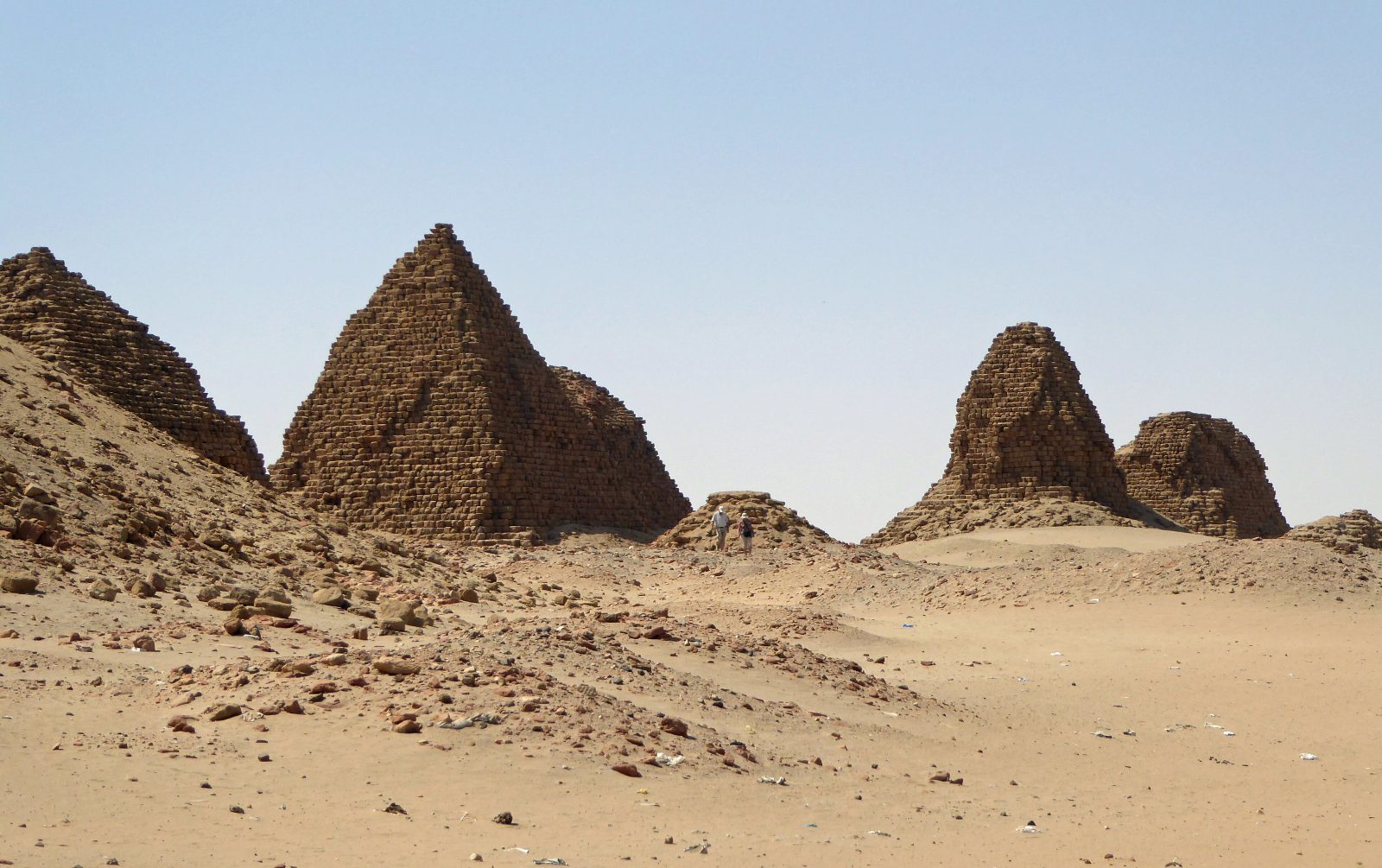
The royal pyramids at Nuri near Napata

750 BC – 350 AD · Kush

Napata & Meroë

The twin capitals of the Kingdom of Kush — Napata the spiritual seat beneath the holy mountain where pharaohs were crowned, Meroë the royal city whose steep pyramids still hold the eastern dunes.

750 ق.م – 350 م · كوش

نبتة ومروي

عاصمتا مملكة كوش التوأمان — نبتة المقرُّ الروحيّ تحت الجبل المقدّس حيث تُوِّج الفراعنة، ومروي المدينة الملكية التي ما زالت أهرامها الحادّة تمسك كثبان الشرق.

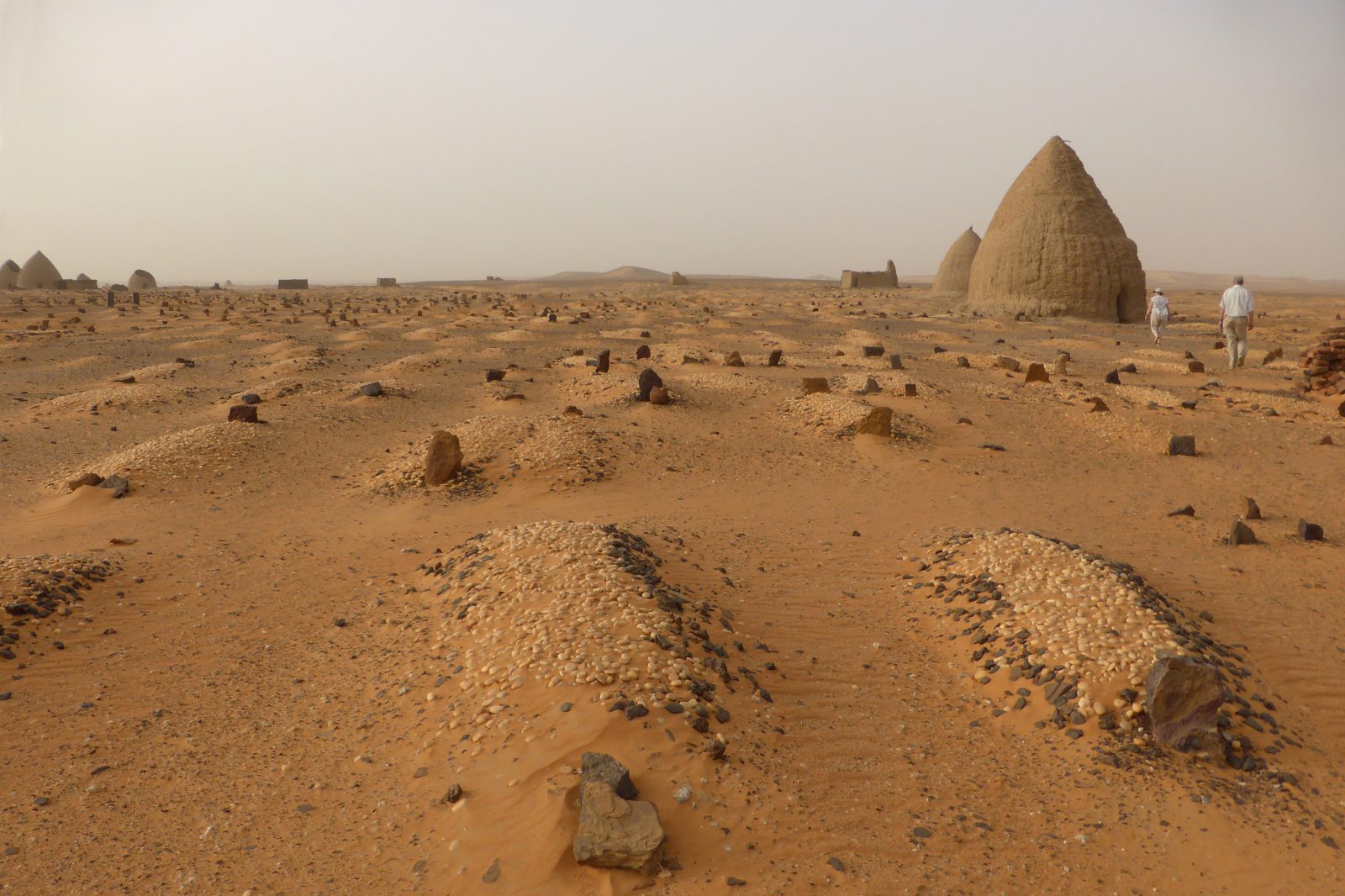
The Throne Hall and qubbas of Old Dongola

6th – 14th century · Makuria

Old Dongola

The cosmopolitan Nubian metropolis of Christian Makuria — its ninth-century Throne Hall became a mosque in 1317, and its pyramidal qubbas still stand over the river road.

القرن 6 – 14 · مقرّة

دنقلا العجوز

حاضرة النوبة العالمية في مقرّة المسيحية — قاعة عرشها من القرن التاسع صارت مسجداً عام 1317، وقبابها الهرمية ما زالت قائمة على طريق النهر.

Ali Dinar Palace · El Fasher

Photograph coming soonالصورة قريباً

18th – 20th century · Darfur

El Fasher

Seat of the independent Darfur Sultanate and hub of the trans-Saharan caravans — the Ali Dinar Palace Museum keeps the memory of the region's last sovereign ruler.

القرن 18 – 20 · دارفور

الفاشر

عرش سلطنة دارفور المستقلة ومحطّ قوافل الصحراء الكبرى — متحف قصر علي دينار يحفظ ذكرى آخر حكّام الإقليم المستقلين.

Sufi qubbas · Abu Haraz

Photograph coming soonالصورة قريباً

Al Gezira · living shrine

Abu Haraz

On the Blue Nile east of Wad Medani, pyramid-pointed Sufi qubbas painted sky blue, pink and green — where ancient Nubian geometry and Islamic devotion share one silhouette.

الجزيرة · مقامٌ حيّ

أبو حراز

على النيل الأزرق شرق ود مدني، قبابٌ صوفية مدبّبة كالأهرام بألوان السماء والورد والأخضر — حيث تتقاسم هندسة النوبة القديمة والتصوّف الإسلامي ظلّاً واحداً.